The Top 10 Questions People Ask a Land Surveyor
Land surveying plays a critical role in property ownership, construction, land development, and infrastructure planning. Despite its importance, many property owners and developers do not fully understand what land surveyors do or when they should hire one. As a professional discipline that combines engineering principles, mathematics, geospatial technology, and legal interpretation, surveying provides the foundation for nearly every project that involves land.
Surveyors establish property boundaries, verify legal descriptions, assist engineers and architects with construction planning, and create reliable spatial data used by government agencies and private industry. Because the work intersects with property law, construction, and mapping technologies, clients often have many questions before commissioning a survey.
Below are the ten most common questions people ask land surveyors, along with professional explanations that clarify the role surveying plays in protecting property rights and guiding responsible development.
1. What Does a Land Surveyor Actually Do?
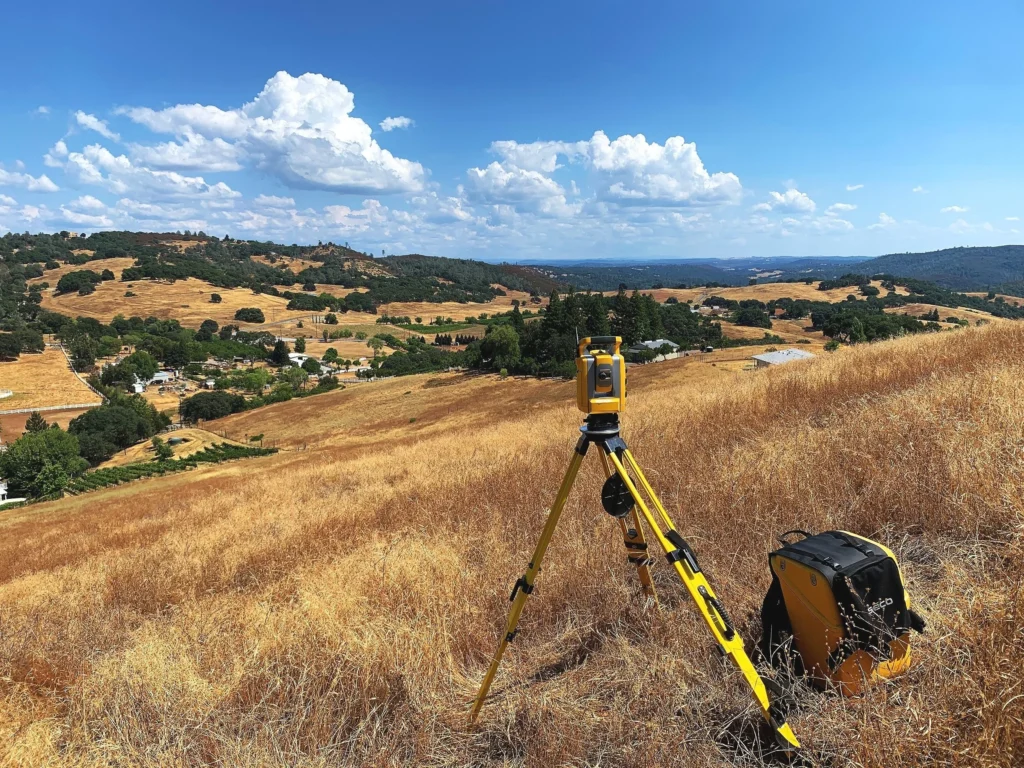
A land surveyor measures and maps the physical features of land while determining the legal boundaries of property. Using specialized instruments such as total stations, GPS receivers, and laser scanners, surveyors collect precise spatial measurements that define where property lines, easements, structures, and natural features exist.
Surveyors also interpret legal descriptions found in deeds, plats, and historical records. These descriptions often reference monuments, bearings, distances, and landmarks that must be carefully analyzed to determine the true extent of a property.
Beyond boundary work, land surveyors support many types of projects. They provide topographic surveys for engineers and architects, construction staking for contractors, subdivision mapping for developers, and geospatial data for public infrastructure projects.
In essence, a surveyor translates legal documents and physical measurements into reliable maps and data that define land ownership and guide construction.
2. When Do I Need a Land Survey?
Property owners often assume surveys are only necessary when purchasing land, but surveys serve many purposes throughout the life of a property.
A survey is typically required when buying or selling property to confirm boundary locations and identify potential encroachments. Mortgage lenders and title companies frequently request surveys before closing real estate transactions.
Homeowners should also obtain a survey before building fences, garages, additions, or pools. Even small structures placed near a boundary can lead to disputes if their location is incorrect.
Developers and contractors rely on surveys before construction begins to ensure buildings, utilities, and infrastructure are positioned correctly according to design plans.
In short, anytime land ownership, construction placement, or property boundaries are involved, a survey provides essential information.
3. How Accurate Are Land Surveys?
Modern surveying technology allows professionals to achieve extremely high levels of accuracy. Depending on the type of survey and equipment used, measurements can be accurate to fractions of an inch.
Surveyors achieve this precision through a combination of advanced instruments and established field procedures. Total stations measure angles and distances electronically, while Global Navigation Satellite Systems (GNSS) receivers determine positions using satellite signals.
Professional standards and state regulations require surveyors to maintain strict accuracy thresholds. Survey data is also checked multiple times during fieldwork and processing to verify consistency.
However, accuracy does not rely solely on equipment. Surveyors must also interpret historical records, locate existing monuments, and reconcile conflicting evidence when determining property boundaries.
The final survey represents the best professional judgment based on physical measurements, legal documentation, and established surveying principles.
4. What Is the Difference Between a Boundary Survey and a Topographic Survey?
Two of the most common survey types are boundary surveys and topographic surveys, each serving a different purpose.
A boundary survey determines the legal property lines of a parcel. The surveyor researches deed records, locates existing boundary markers, measures the property, and sets or verifies monuments that define the parcel’s limits.
A topographic survey focuses on the physical features of the land rather than legal boundaries. It maps terrain elevations, slopes, trees, structures, utilities, drainage patterns, and other site characteristics.
Engineers and architects rely on topographic surveys when designing buildings, roads, drainage systems, and utility infrastructure.
Many projects require both types of surveys because accurate boundary information and terrain data are equally important during planning and construction.
5. How Much Does a Land Survey Cost?
The cost of a land survey varies widely depending on several factors. Property size, terrain complexity, accessibility, and the amount of historical research required all influence pricing.
Urban residential surveys typically cost less than surveys for large rural parcels because smaller properties require less field time and research.
However, properties with unclear boundaries, missing monuments, or conflicting records can increase survey costs due to additional investigative work.
Construction and engineering surveys may also cost more because they involve higher levels of detail and repeated site visits during the building process.
While survey costs vary, the service provides significant value by preventing costly property disputes, construction mistakes, and legal complications.
6. How Long Does It Take to Complete a Survey?
Survey timelines depend on the type of survey and project complexity. A straightforward residential boundary survey may take a few days to complete, while large or complex surveys can require several weeks.
The process typically involves three main stages.
The first stage is research. Surveyors review historical records, deeds, plats, and previous surveys to understand the property's legal description.
The second stage involves fieldwork. Survey crews visit the site to locate monuments, measure distances, collect GPS data, and document physical features.
The final stage is data processing and drafting. Surveyors analyze field measurements, reconcile boundary evidence, and produce official maps or plats.
Weather conditions, record availability, and project scope can all influence the timeline.
7. What Is a Property Monument or Marker?
Property monuments are physical markers that identify the corners or boundaries of a parcel. They serve as permanent reference points for determining property limits.
Common monument types include iron rods, pipes, concrete markers, stone monuments, and metal survey caps stamped with a surveyor’s license number.
Surveyors locate existing monuments during fieldwork and verify whether they match recorded property descriptions.
If monuments are missing or disturbed, surveyors may place new markers in accordance with state regulations.
These markers are extremely important because they represent the legally recognized boundaries of a property. Moving or removing them can create significant legal issues.
8. What Happens if My Neighbor’s Fence Is on My Property?
Encroachments occur when structures such as fences, sheds, driveways, or buildings extend across a property boundary.
If a survey reveals that a neighbor’s structure crosses onto another property, several solutions may be considered.
Property owners often resolve minor encroachments through communication and agreement. In some cases, neighbors may adjust or relocate the structure.
Other situations may require legal agreements such as easements or boundary adjustments to formalize the arrangement.
If disputes cannot be resolved amicably, the issue may require legal review. Survey documents often serve as key evidence in these situations.
The best way to prevent encroachment problems is to obtain a survey before building fences or other structures near property lines.
9. What Is Construction Staking?
Construction staking is the process of transferring building design plans from paper or digital models onto the physical site.
Surveyors place stakes or markers that show contractors exactly where foundations, roads, utilities, and structures should be built.
These stakes guide construction crews and ensure that structures are positioned correctly according to engineering plans and zoning requirements.
Construction staking typically occurs in phases. Initial staking may mark building corners or centerlines. Later staking may define grading elevations, utility alignments, and final layout details.
Without accurate staking, contractors risk building in the wrong location, which can lead to costly corrections.
10. Why Is Land Surveying Still Important in the Age of GPS?
Many people assume that GPS technology has simplified surveying to the point that professional surveyors are no longer necessary. In reality, modern surveying requires more expertise than ever.
While GPS provides powerful positioning capabilities, the technology alone cannot interpret legal property descriptions, resolve boundary conflicts, or determine land ownership.
Surveyors integrate satellite positioning with traditional measurements, historical records, and legal principles to produce defensible boundary determinations.
Professional surveyors also ensure that measurements meet regulatory standards and can withstand legal scrutiny if disputes arise.
Technology has enhanced surveying tools, but the knowledge and judgment of licensed surveyors remain essential.
Conclusion
Land surveying provides the critical framework that supports property ownership, construction, infrastructure development, and environmental planning. Every boundary line, building layout, and subdivision map relies on accurate measurements and professional interpretation.
The questions discussed above represent the concerns most property owners and developers encounter when dealing with land boundaries and site development. Understanding these concepts helps clients make informed decisions and avoid common pitfalls associated with property disputes and construction errors.
Ultimately, a professional land survey provides clarity. It defines property limits, supports responsible development, and ensures that landowners understand exactly what they own and where their rights begin and end.
Footnotes
1. https://www.nsps.us.com
2. https://www.asce.org
3. https://www.blm.gov/programs/lands-and-realty/cadastral-survey
4. https://www.fgdc.gov
5. https://www.ncees.org